Geographical position
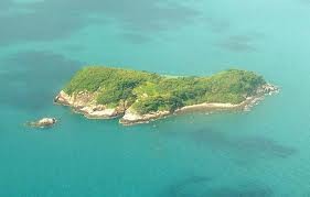
Ha Long Bay is located in the northeast corner of Viet Nam, 165 km from Ha Noi. In the Province of Quang Ninh. Ha Long Bay covers an area of 1,553 km2 with 1,969 islands, of which 90% are limestone islands. To the west and north west, Ha Long Bay stretches from Yen Hung district in Ha Long city to Cam Pha town in Van Don district; to the south-east and in the south, Ha Long Bay borders the western shore of Tonkin Gulf; to the southwest the Bay borders Cat Ba island (Hai Phong province).
In 1962, Ha Long Bay was recognized as a vestige and beauty spot of national significances by Ministry of Culture and Information of Viet Nam and was also recognized as a world national heritage site twice by UNESCO organization. The first time, in 1994 for the exceptional and universal value of the landscape and the second time in 2000 for the special value of geology and geomorphology.
Ha Long Bay’s center area was regognized as a world heritage area by UNESCO and covers an area of 434 sq. Km, including 775 islands, of which 411 are named. It is bound by Dau Go island( in the west), Dau Be island (in the south) and Cong Tay island(in the east).
A buffer zone lies around the World Heritage Area, the width is about 5 - 7 km from the protection line to the sea , on moving scale of 1-2 km.
Climate
The climate of Ha Long Bay is tropical, being wet and hot. It is devides into four main seasons: winter is from November to March of following year, the temperatures drop to between 15oC - 20oC. Summer is from May to September, the temperatures increases to between 26oC-27oC Two others seaons: Spring and Autumn, climate is cool. The annually average temperature between 18oC - 19oC.
Annual rainfall averages from 2.000mm- 2.200mm. The salinity of seawater divides into between seasons: rainy season 21‰-22‰, dry season 32‰-33‰.. The bottom of bay is quite flat with the average depth of 5 -10m, in some parts 15-29m depth. There are narrow passages such as: Cua Luc(20m), The Vang(22-27m) and the others with 9-10m depth. Thanks to the system of islands and islets, the waves in Ha Long Bay are quite light, here is a uniform daily tide vanation of 3,5-4m. The low spring tides in March, April, August and December, the highest tide is in January, June, July and December.
History of the name”Halong”
The name Ha Long is literally translated as “Descending Dragons”. Prior to the 19th century, this name was not recorded in any documents or archives. When mentioning the present-day Ha Long Bay, old historical books often referred to them as the seas of Giao Chau, Luc Chau, Luc Thuy, Van Don, Hai Dong or An Bang. Not until the late 19th century did the name Ha Long Bay appear on the Bac Bo Gulf (Tonkin Gulf) chart of the French.
So when did the name Ha Long Bay originate? A legend has been handed down in the local area relating to the name Ha Long Bay, which says:
“Long ago, in the first founding days, the Viet people were attacked by foreign aggressors. The Jade Emperor sent the Mother Dragon and a herd of Child Dragons to help the Viet fight the invaders. While the enemy vessels were launching massive attacks against the mainland, the dragons descended in flocks from the sky. They spat out innumerable pearls which, in a moment, were changed into innumerable stone islands linked together into a firm citadel that checked the enemy’s advance and smashed their vessels into pieces.
After the invaders were driven out, Mother Dragon and her Child Dragons did not return to Heaven but stayed on earth, right at the place where the battle occurred. The spot where the Mother Dragon landed was Ha Long, and where the Child Dragons came down was Bai Tu Long. The place where their tails violently wagged was called Long Vi( present Tra Co peninsula).
The Legend glued to the orgination of children of the Fairy and the Dragon. Dragon and fairy symbilized to the traditional strength of fatherland and the poetic name of this area , which named by the local people. Nowadays, many names of islands and islets on Halong Bay contains Dragon(Rong) like: Dau Rong(Dragon head), Mat Rong(Dragon eyes), Hon Rong(Dragon Islets), Cai Rong anf faraway Long Chau, Bach Long Vi(White Dragon tail).

Thursday, 20 October 2011
Tuesday, 7 June 2011
Hoi An Ancient Town, a World Cultural Heritage Site
Hoi An is an old town down the Thu Bon River, on the coastal plain of Quang Nam Province, about 30 km south of Danang City. Hoi An used to be known on the international market with many different names such as Lam Ap, Faifo, Hoai Pho and Hoi An.

What is so special about Hoi An is that this little port town is in an incredible state of preservation. It offers some of the most densely-concentrated sights in Vietnam with its old streets bordered with ancient houses and assembly halls, its pagodas, temples, ancient wells and tombs. In total, more than a thousand places of interest. The architecture of Hoi An is characterised by a harmonious blend of Vietnamese, Chinese and Japanese influences. After many centuries, Hoi An is still respectful of its traditions, folk festivals, beliefs and of its sophisticated culinary art. Set in a quiet environment, Hoi An is surrounded by peaceful villages that have crafts such as carpentry, bronze making, ceramic ...
Researchers said most of the buildings in Hoi An underwent restoration at the beginning of the 19th century, even if they might be constructed long time ago. The ancient architecture shown most clearly in the Ancient Town that located in Minh An Ward. It covers about 2 square kilometres and almost of all famous relics in Hoi An are gathered here. The streets are very short and narrow, having a winding, crossing as the chessboard style. The topography of the ancient town tilt gradually from north to south. The buildings in the old town is built mostly with traditional materials such as: brick, wood and no more than two floors. The traces of time is able to find not only on the architectural design of each building but also everywhere like: on the yin-yang roof tiles covered with moss and plants; the old gray mold walls; the pictures carved on a strange animal, or describing a old story… Having inherited a multi-cultural architecture so varied and sophisticated, Hoi An must have attracted numerous and talented workers in carpentry, ceramics, and woodcarving from China, Japan and other regions of Vietnam.
For centuries, Hoi An had developed into a melting pot of various nationalities who came to the area, bringing along their own cultures. Accordingly, Hoi An features the co-existence of indigenous customs and habits and those imported by foreign settlers.
There are animist cults, of the Genie-Whale and worship of deities of natural phenomena (such as rain, wind, thunder), but also the worship of Holy Protectors like Thien Hau, Quan Cong, Bao Sinh Dai De, Avalokitesvara, especially among the Chinese community. They hold regular festivals or cultural and religious activities on the occasion of Tet Nguyen Tieu (the 16th day of the 1st lunar month), Thanh Minh (3rd lunar month), Doan Ngo (the 5th day of the 5th lunar month), Trung Thu (the 15th day of the 8th lunar month), Trung Cuu (the 9th day of the 9th lunar month), and Ha Nguyen (the 15th day of the 10th lunar month).
The social and cultural diversity adds up to the uniqueness of Hoi An’s inhabitants.
Rich in traditions and early exposed to the outside world, the Hoi An people feature a unique cultural identity, which has been well preserved from generation to generation. Lives of people who stay here incline to be interior with subtle quiet. In the mind of the natives of Hoi An, this town constitutes a large ancient home that shelters a big family of many descendants including hospitable dwellers, friendly hosts and hostesses, kind-hearted women, obedient children and so on. They together form a harmonious community who has lived peacefully side by side through successive generations.
Upon reaching Hoi An, visitors will immediately feel the hospitality and friendship the locals extend to them. One thing that has withstood the test of time, one thing that the Hoi An people today can be proud of and therefore, make every efforts to preserve is their popular ho (chants) and age-old cultural festivals. Among them, the "Nights of Hoi An" is held on the 14th night of every lunar month. Visitors can immerse themselves in a festive atmosphere imbued with the traditional identities of Hoi An.
The architectural significance of Hoi An has been recognized by UNESCO, during the 23rd Congress which took place in Marrakech (Morocco) from the 29th of November to the 4th of December 2009, since the town was officially listed as a World Cultural Heritage Site.
My Son Sanctuary
Geographical position
My Son Sanctuary is set in a small valley belonging to Duy Phu Commune, Duy Xuyen District, Quang Nam Province, about 70km southwest of Danang City and 40km from Hoi An City. Of the 225 Cham vestiges that are founded in Vietnam, My Son possesses 71 monuments and 32 epitaphs, the content of which is still being studied.
History
The Cham Kingdom had two sanctuaries belonging to two main opposing clans. My Son of the Dua Clan, ruled over the north of the kingdom and was the place for the worship of God Srisana Bhadresvara. The Cau Clan, who reigned over the south had Po Nagar Sanctuary, dedicated to Goddess Po Nagar. Nevertheless, My Son was considered as the sanctuary of the Cham Kingdom.

The first constructions date back to the 4th century under the reign of Bhadravarman for the worship of God Shiva-Bhadresvara. But later on, the temple was destroyed. At the beginning of the 7th century, King Sambhuvarman had it rebuilt and rebaptized Sambhu-Bhadresvara. Each new monarch came to My Son after his accession to the throne, for the ceremony of purification and to present offerings and erect new monuments, which explains why My Son is the only place where Cham art flourished without interruption from the 7th to the 13th century.
Architecture in My Son
The temples in My Son were built into groups that basically followed the same model. Each group was comprised of a main sanctuary (kalan), surrounded by towers and auxiliary monuments. The kalan, which is a symbol of Meru Mountain (centre of the universe, where the gods live) is dedicated to Shiva. The small temples are devoted to the spirits of the eight compass points. In the towers, topped with tiled, curved roofs, were stocked the offerings and sacred objects of the pilgrims. Cham temples do not have windows, so they are very dark inside. Windows are only found on the towers.
Cham towers and temples are built of bricks associated with sandstone decorations. It is quite noteworthy that no adhesive can be seen in between the bricks, which is amazing since some of the works have survived thousands of years. The structures were built, and only then did the sculptors carve the decorations of floral patterns, human figures or animals. This technique is unique in Asia.
Every kalan in My Son is comprised of three parts: the bhurloka (foundations), the bhurvaloka (body of the tower) and the svarloka (roof).
The bhurloka represents the terrestrial world. It is decorated all the way round by engravings of patterns, animals, human characters praying under small vaults, masks of Kala or Makara (monsters), dancers, musicians…
The bhurvaloka symbolises the spiritual world where, after being purified, men could meet the ancestors and the gods. It is built with very thick bricks (about 1m thick), but its height can vary from one monument to the next. The outside is decorated with pilasters, false doors or windows.
The svarloka usually has three storeys in the same style as the base, and features a main door and other, false, ones. It is decorated with small sandstone or brick statues representing mythical animals, which are mounts ridden by gods in the Indian tradition: birds, swans, buffaloes, elephants or lions. There are small decorative towers at the corners of the 1st and 2nd storeys. This roof, made of sandstone or brick, can be either pyramidal or boat-shaped.
Methods used to identify and categorise the style of the My Son Sanctuary
In 1895, C. Paris, a French scholar, was the first one to clear the My Son Sanctuary. Then, many scientists came to My Son to study Cham epitaph, sculpture and architecture such as Henri Parmentier, C. Carpeaux, P. Stern…
Thanks to Henri Parmentier, the temples of My Son were classified into groups of letters (A, A’, B, C, D, E, F, G, H and K), and then numbered according to their functions. It starts with the main sanctuary, the kalan, (number 1), then the gate tower (number 2), and so on. Even though these categories break up the architectural complex of My Son as a whole, they are remarkably efficient for the study and maintenance of the ruins.
In December, 1999, at the 23th meeting of World Heritage Committee of UNESCO in Marrakesh, Marocco, My Son was recognised as world cultural heritage based on two prominent criterions: typical example about cultural exchange and unique evidence of disappeared Asia civilization
Con Dao


Today the prisons serve as a stark reminder of the horrors of war, and many of the islands residents are ex-convicts who decided to stay on the islands rather than return to the mainland. These days the main industries are fishing and shipping, and life on the island is very simple and undeveloped, though there are plans to encourage more tourism to the islands in the future.

On our visit we hired a motorbike to explore the roads around the island, and went for hikes through the forest and swam on completely deserted beaches, as well as visiting the prisons and museums. It was a true escape from Saigon, a complete contrast to the concrete, traffic and noise, and one we'll remember forever.
One of the key organisations protecting the local habitat in Con Dao - as well as in many other national parks across Vietnam - is WWF. If you'd like to help support conservation efforts in Vietnam and preservation of the many endangered species there, we strongly suggest becoming a member - it doesn't cost a lot and while in Vietnam you can see for yourself the difference they are making.
Getting to Con Dao
If you want to go by boat there is a hydrofoil service from Vung Tau to Con Dao twice a week at 350,000 VND each way, and also one departing from Tra Vinh in the Mekong Delta which is run by Greenlines. The fares and timetable are no longer advertised on the Vietnamese language version of their website though, so it is worth checking before making the trip to Vung Tau.
Flights are run by VASCO but are unfortunately not bookable online.
An alternative may be to book online with Isango who are currently advertising an all inclusive two day tour to the island including flights which departs from Ho Chi Minh City. Feedback on this service would be appreciated.
Tuesday, 10 May 2011
Da Lat
Nestled 1,500 meters above sea level on the Langbiang Plateau in the southern area of Vietnam's Central Highlands, the picturesque landscapes of Lam Dong Province's Da Lat Town attract large numbers of tourists annually.
Thanks to its fresh, cool air, majestic waterfalls and thousands of brilliant flowers, the community is a favorite destination for both Vietnamese and foreign visitors alike. The name Da Lat originates from the ancient hill tribe people who once populated the region and means "stream of the Lat people."
Arriving in Da Lat, situated 320 kilometers from Ho Chi Minh City, tourists are always astonished at the town's overflowing bounty of flowers.
Blossoms can be seen everywhere in countless varieties including orchids, mimosas, pansies, wild sunflowers and roses. There are also many rare types of flowers found in few other places in the country.
The easiest to spot are the orchids, dubbed locally as "queen of the flowers." Of the world's 100,000 species of orchids, as many as 500 types are grown in the town.
Da Lat also boasts a unique species of orchid called lan hai, which received much attention and praise when it was displayed at an orchid exhibition in Tokyo, Japan a few years ago.
The flower was named for its resemblance to a type of embroidered shoe worn by noble women, known in Vietnamese as "hai."
Another popular type of Da Lat flora is the mimosa, a six-meter-tall tree with small yellow flowers which grows only in hot countries.
The tree, which originates from Australia, comes into bloom three times a year during the dry season. Da Lat is home to two types of mimosa trees, one is a long-leafed variety and the other is short-leafed.
Local songwriter Tran Kiet Tuong found great inspiration in the mimosa and wrote a song based on the tree's beauty.
According to folklore, Da Lat girls would often place mimosa flowers between the pages of a book, and then send it to their boyfriends. The pressed flowers would retain their sweet scent, and act as a fond reminder of the girls. Like the mimosa itself, this practice is said to have stemmed from Australia.
Among thousands of varieties of flowers, the Da Lat rose is a particular favorite nationwide. Aside from being sold in the town's markets, roses are also transported to larger markets in other provinces and cities, including Hanoi and HCMC.
The flowers come in all sort of colors and shades including pink, violet and yellow.
The yellow roses are known locally as "Josephine," after the wife of Napoleon Bonaparte, while other roses are also referred to after famous movie stars and nobility.
Watercolor waterfalls and more
The town of Da Lat is also well known for its breathtaking waterfalls, including the Prenn, Cam Ly, Dambri and Pongua.
Prenn Waterfall, located at the foot of Prenn Pass and about 10 km from the center of Da Lat, is considered a symbol of the town. Behind the cascading water is a bamboo bridge where visitors can cross through a spray of refreshing mist. Tourists can also explore the surrounding area, home to a wide variety of animals.
Locals compare the scenery at Prenn Waterfall to that of a watercolor painting. The water pouring over the top of the fall creates a sheet of silver, which flows into a swirling pool of white foam at the bottom. A nearby photo shop allows visitors to have their photo taken at the falls to commemorate their trip.
Tourists can also take a horse or elephant ride while touring the area, or rent a canoe to discover the waterfall's surrounding canals.
Nearby Xuan Huong Lake, spanning five square kilometers, is another picturesque area and popular with honeymooners.
This manmade lake, which was named after famous Vietnamese poet Ho Xuan Huong who lived in the 18th-century, was also a site where many indigenous people of Highland Langbian ancestry made their homes.
In 1984, scientists found many ancient relics at the bottom of the lake belonging to the hill tribes that once lived in this area.
Another well-known Da Lat lake is Tuyen Lam, located five kilometers south of the town.
Tuyen Lam is known as the lake where rivers, springs and forests converge. The immense area stretches over 350 hectares from the beautiful Tia Spring and Da Tam River to Voi Mountain.
Da Lat is also known for its Valley of Love, known in Vietnamese as Thung lung tinh yeu.
Situated about five kilometers outside of town and spanning about 242 hectares, the Valley of Love is filled with scenic, rolling pine tree-clad hills, perfect for picnics.
For those who love to hike, the 1,900-meter tall Lang Biang Mountain takes around three hours to climb. For others who would rather drive up, jeeps can be hired for around US$10.
Other tourist attractions in Da Lat Town include the Da Lat Market, Lake of Sighs, and the summer Palace of Bao Dai, the last king of Vietnam.
According to Sato Kohara, a Japanese fine arts student touring the area, "I have visited many sites in Vietnam, but still felt surprised when I arrived here. This site is peaceful, romantic and fresh.
"If I have a chance to visit Vietnam again, I will return to this site together with my friends," she adds.
Phu Quoc Island
The tear-shaped Phu Quoc (Vietnamese Phú Quốc) is part of the Kiên Giang province. The distance from Phú Quốc to mainland Viet Nam is 45 km to Hà Tiên and 120 km to Rạch Giá. The island is 50 km long (from north to south) and 25 km wide (from east to west at its widest part).

Surrounded by more than 40 km of white beaches decorated with coconut palms, Phú Quốc, situated in the Gulf of Thailand near the Cambodian border, is Vietnam’s largest island. Its western coastline is sparsely populated while the interior is largely covered with jungle and mainly deserted.
You can start exploring the island in Dương Đông, the biggest town on the island (west of Phú Quốc), where most of hotels and resorts are located. Going south, you can drive along Bãi Trường (Long Beach), which is a 20 km long, spectacular beach. You will see two pearl farms on the right, the second is worth a visit. At the end of the road turn left (you can’t miss it) and follow the signs, you will reach the fisherman village An Thới and the An Thới pier, the island’s southern tip. From here the An Thới Islands, a very nice snorkelling and diving area consisting of 15 small islands and islets surrounded by coral reefs in crystal clear water, can be visited by boat.
Continuing to travel north-east, you will see a sign to Bãi Sao (the sign is somewhat hidden, around 1 km away from the main road). Bãi Sao, with its marvelous white sand and green-turquoise water, is one of the most beautiful, quite untouched beaches on Phú Quốc Island. There are a number of simple, on-the-sand restaurants with tasty, fresh seafood in this area.
Before going back to Dương Đông, there are some recommendable springs and falls: Suối Tranh and Suối Đá Bàn. Suối Tranh (some 10 km north of Bãi Sao) is a stream connecting tiny ponds at different levels through small waterfalls. Suối Đá Bàn (a stony surface stream, north-east of Dương Đông) is an easily accessible white-water creek, gracefully flowing down huge granite boulders, on which you can wake; in some places there are natural pools waiting for a refreshing swim.
A stay on Phú Quốc Island would not be complete without visiting one of the factories producing Nước Mắm (fish sauce), one of the most popular ingredients of the Vietnamese cooking as well as one of the pearl farms with panels describing the formation of pearls and shops selling pearl jewellery.
The island has a unique species of dogs, the Phú Quốc Ridgeback, which has a ridge of hair that runs along its back in the opposite direction to the rest of the coat. Much of this island’s nature is still protected. Around 70% of the island, an area of 31,422 hectares, became a national park in 2001. The rainy season on Phú Quốc is from July to November and the peak season for tourism is midwinter, when the sky is blue and the sea is calm.
Travelers who know the Thai islands Ko Samui and Phuket often comment: “The island of Phú Quốc is still natural and untouched like Ko Samui 10 years and Phuket 20 years ago”. Not surprising, a larger international airport is being built on the island of Phú Quốc, expected to operate within five years. A golf course and a casino will also be completed. If you like untouched nature and pre-touristic surrounding, you should hurry up!


Cu Chi tunnel
 Cu Chi Tunnel is 70 km from Ho Chi Minh City in the Northwest. It is miniature battle versatile of Cu Chi’s military and people during the 30-year struggle longtime and fierce to fight invading enemy to receive independence, freedom for motherland. It also is the special architecture lying deeply underground with many stratums, nooks and crannies as complex as a cobweb, having spares for living, meeting and fighting with total lengths over 200 km. Real legends coming from the Tunnel are over human imaginativeness. Creeping down into the tunnel, only some yards, you can find out why Vietnam? A tiny country could defeat its enemy, the large and richest country in the world. Why Cu Chi, a barren and poor land could face strongly for 21 years to the army crowded many times compared with its force, warlike and equipped modern war weapons and means. In the fight, Cu Chi people won illustriously. Thanks to systems of tunnel ways, fortifications, combat trenches, soldiers and people of Cu Chi fought very bravely creating glorious feat of arms. The American invaders at first time stepped into Cu Chi land, they had to face so fierce resistances from tunnels from important and very difficult bases that they cried out, “Underground villages”, “Dangerous secret zone”, “cannot see any VC but they appear everywhere”… With its war pasture, Cu Chi Tunnels become a historical war hero of Vietnamese People like a 20th century legend and famous land in the world.
Cu Chi Tunnels have two places:
Ben Duoc Tunnels is Zone Party Committee Base & Saigon – Gia Dinh Military Zone, which is protected in Phu Hiep Hamlet, Phu My Hung Village, Cu Chi District, Ho Chi Minh City.
Ben Dinh Tunnels is Cu Chi District Party Committee, which is protected in Ben Dinh Hamlet, Nhuan Duc Village, Cu Chi District, Ho Chi Minh City. Coming to Ho Chi Minh City, you should visit Cu Chi Tunnels Historical Monument to understand what the protracted and arduous struggle is. You will evidence clearly and directly an exploit of loving peace, independence and happiness at the present.
[Source:http://www.cuchitunnel.org.vn]


Subscribe to:
Comments (Atom)